A view of the old Copthill churchyard. The part in the centre where there are no flowers is the site of the Church. As quarrying to the left of the photo began to erode the ground, the Church was moved in 1915, stone by stone, to its present site in the village. The headstones are still there, dating back to 1823. The Hill can be seen next to the tree in the centre. The houses in the background are the ones featured earlier in the blog, around Wellhope, Rush and Allers.
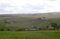
Showing posts with label Lanehead in Weardale. Show all posts
Thursday, 24 June 2010
Friday, 18 June 2010
Down dale from Copthill
A view from just beyond Copthill. The old Copthill Churchyard can been seen at the centre left of the photo with Bridge End Cottage below. At the right is Bents and beyond that the houses of Irestone, which is just above Vedra Close in Wearhead. The trees at the top are Hawkwellhead Wood, above Ireshopeburn. The farm at the top right is Ireshope Plains, where the television mast for the top end of the dale is situated.
Thursday, 17 June 2010
Gatehouse
Wednesday, 16 June 2010
Low Allers
Tuesday, 15 June 2010
High Allers
Looking across from the main road again is High Allers. The track up to the house goes down to the river and then up the wall at the centre of the photo. It belonged to the Dalton family for many years but was sold 2 or 3 years ago and renovated. It is now for sale again at the moment, by clicking here you can see more photos and details from the estate agents.
Monday, 14 June 2010
Allers Lea & Low Moss
A few yards down the road and looking over the other side of the valley again we see Allers Lea at the bottom of the left photo, Birch Hill in the centre and Low Moss at the top. The photo on the right shows Low Moss with the zoom on. My maternal ancesters used to live at Moss, as well as Rush. The track I followed past High & Middle Rush continues past the wall at the bottom of the photo and then onto Low Allers, right next to the river.
Sunday, 13 June 2010
Cornriggs Post Office & Traveller's Rest
Saturday, 12 June 2010
Friday, 11 June 2010
Low Rush & Hill Top
Thursday, 10 June 2010
Low Burnt Hills
Across the river from High & Middle Rush there are a few houses called Low Burnt Hills, seen at the bottom of the photo. The houses of Lanehead can be seen behind with Cornriggs at the top right. Low Burnt hills cannot be seen from the main road, nor by walking down the river side, so it was nice to get a photo of the area. The building at the top left is Lanehead School shown earlier, and the last house going down the bank School House, shown the same day.
Wednesday, 9 June 2010
Tuesday, 8 June 2010
High Rush
Monday, 7 June 2010
Blakeley Field and Rush
Walking uphill and down parallel with the river, I walked past Blakeley Field, on the left photo. This is the home of the Taylors who run an adjoining self catering cottage, Beckleshele Cottage which has a website with all their informion and some lovely photos.
The photo on the right shows Far Rush or Lanehead View, different names on various maps. Blakeley Field can be seen int he background, and Killhope Wood behind that. These cottages have wonderful views looking right down the dale.
Sunday, 6 June 2010
Sparty Shield
Saturday, 5 June 2010
Down through Weardale
The road to Wellhope forks to the left (left photo)and this takes you past South Wellhope Farm,
Whitestone House and Stout's Close. I turned a 90 degree angle, so the photo on the right shows a view looking down Weardale from a few yards through Wellhope Gate. By clicking on it and zooming in you can see it shows Low Burnt Hills in the centre, the white house at the top left is The Gatehouse. Through the trees at the right is the back of Allerslea, and well in the background, in the centre, our house can be seen with the road to Sedling behind.
Friday, 4 June 2010
Wellhope
After leaving Wellhope Gate the first house to see is High Byre, shown on the photo on the right. Part of Killhope Wood which was behind it has recently been felled and replanted. Farther along the track is Woodside and Wellhope House, shown on the left photo. These houses all belong to Weardale Estates and are lived in by estate workers and retired estate workers. Wellhope House was lived in for many years by the Dalton family, which consisted of 6 sons and 6 daughters. The moors behind are used for grouse shooting from August onwards.
Thursday, 3 June 2010
Lanehead Chapels
Greenlaws on the left used to be Lanehead Zion Primitive Methodist Chapel. It was built in 1834 and extended on the right side in 1858. It closed in 1948 and sold off as a priva
There was also a Weslyan Chapel a few yards down the road which also closed in 1948 and was demolished in 1950.
The photo on the right shows a view looking from Wellhope gate up through Killhope Wood. The houses are Cleugh House Farm and behind that is Cleugh Head Cottage. The road cannot be seen, but is the highest road in England.
Wednesday, 2 June 2010
Lanehead Schools
On Monday I walked up to Lanehead and over to Wellhope and Rush to take some photos. The left one shows The school House at the bottom of Lanehead Bank. It was built by Bishop Shute Barrington about 1819 and used as the school. It was used until the larger school on the right was built, at the top of the bank, in 1874. The new mixed and infants school had room for 144 pupils and in 1894, according to Whellan's Directory, was attended by 80 pupils. Some pupils left at 11 years old to attend Wolsingham Grammar School, the others stayed at Lanehead until they left their education. In 1958 Wolsingham became a Secondary School, so all pupils over 11 years old moved schools. The decline in pupil numbers at local schools meant closures, and Lanehead was closed in 1959 and pupils transferred to Wearhead School. The School House was sold in 1908 and the money was used to help build the Cowshill Village Hall, then called the Mission Room.
Subscribe to:
Posts (Atom)